1. Isobars - Sydney Observatory
advertisement
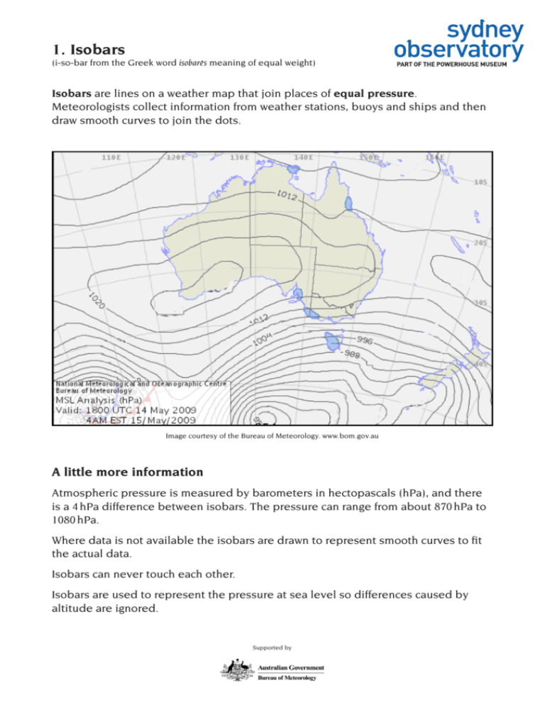
1. Isobars (i-so-bar from the Greek word isobares meaning of equal weight) Isobars are lines on a weather map that join places of equal pressure. Meteorologists collect information from weather stations, buoys and ships and then draw smooth curves to join the dots. Image courtesy of the Bureau of Meteorology. www.bom.gov.au A little more information Atmospheric pressure is measured by barometers in hectopascals (hPa), and there is a 4 hPa difference between isobars. The pressure can range from about 870 hPa to 1080 hPa. Where data is not available the isobars are drawn to represent smooth curves to fit the actual data. Isobars can never touch each other. Isobars are used to represent the pressure at sea level so differences caused by altitude are ignored. Supported by 2. Pressure cells When the isobars form a closed loop, a cell is produced. The air flows anticlockwise in high pressure cells (H) and the weather is generally stable. The air flows in a clockwise direction in low pressure cells (L). Lows often bring unsettled weather. Image courtesy of the Bureau of Meteorology. www.bom.gov.au A little more information There is some cross-isobar flow — the air generally spirals gently outward from the centres of high pressure and spirals in towards the centres of low pressure. In the northern hemisphere the flow is in the opposite direction around highs and lows. The spiralling is caused by the Earth’s rotation and is known as the Coriolis effect. Contrary to popular opinion it does not affect water going down the drain. Supported by 3. Rainfall Actual and possible rainfall is indicated on black and white maps as a series of diagonal lines, or as blue-filled shapes on colour maps. Rainfall can also be predicted from the isobars and pressure cells on a weather map. Intense low pressure cells coming off the ocean, such as cyclones, always bring heavy rain to coastal areas. The rain may also extend inland. Image courtesy of the Bureau of Meteorology. www.bom.gov.au A little more information Rainfall is measured in millimetres (mm) and the Bureau of Meteorology uses a tipping bucket rain gauge on Observatory Hill for some of its data collection. Supported by 4. Fronts A front is the moving border between two air masses that typically results in clouds. A cold front usually brings west to southwest winds, sudden drops in temperature and sometimes thunderstorms. Cold fronts are drawn on weather maps as a line with solid triangles. Warm fronts are rare over mainland Australia and form clouds with the possibility of rain. Warm fronts are drawn on weather maps as a line with solid semicircles. Image courtesy of the Bureau of Meteorology. www.bom.gov.au A little more information A cold front occurs when a mass of cold air slides under warmer, less dense air. As the warm moist air is pushed upwards, it forms clouds. Warm fronts occur when a mass of warm air slides up and over the cold air. As the warm air rises, it forms clouds. Supported by 5. Wind Wind is not shown on a weather map but other information helps predict its path and strength. Wind flows from high to low pressure areas. High pressure cells flow anticlockwise and low pressure cells clockwise. Winds are usually stronger where the isobars are close together. Wind is named for the direction it comes from, so a southerly comes from the south. Image courtesy of the Bureau of Meteorology. www.bom.gov.au A little more information Although wind flows from high to low pressure areas, it does not flow at right angles to isobars as expected. The rotation of the Earth causes the winds to circulate around pressure cells in a spiral fashion. Wind speed is measured by an anemometer and is generally measured in km/h. The marine and aviation industries use knots. The Beaufort scale is also a measure of wind speed. Supported by
