Hoërskool Nylstroom
advertisement
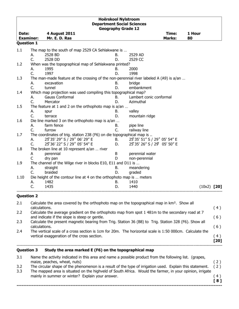
Hoërskool Nylstroom Department Social Sciences Geography Grade 12 Date: Examiner: Question 1 4 August 2011 Mr. E. D. Ras Time: Marks: 1 Hour 80 1.1 The map to the south of map 2529 CA Sehlakwane is … A. 2528 BD B. 2529 AD C. 2528 DD D. 2529 CC 1.2 When was the topographical map of Sehlakwana printed? A. 1995 B. 2000 C. 1997 D. 1998 1.3 The man-made feature at the crossing of the non-perennial river labeled A (A9) is a/an … A. excavation B. bridge C. tunnel D. embankment 1.4 Which map projection was used compiling this topographical map? A. Gauss Conformal B. Lambert conic conformal C. Mercator D. Azimuthal 1.5 The feature at 1 and 2 on the orthophoto map is a/an … A. spur B. valley C. terrace D. mountain ridge 1.6 Die line marked 3 on the orthophoto map is a/an … A. farm fence B. pipe line C. furrow C. railway line 1.7 The coordinates of trig. station 238 (F6) on die topographical map is .. A. 25̊ 35’ 29” S / 29˚ 06’ 29” E B. 25̊ 35’ 51” S / 29˚ 05’ 54” E C. 25̊ 36’ 22” S / 29˚ 05’ 54” E D. 25̊ 35’ 26” S / 29̊ 05’ 50” E 1.8 The broken line at 10 represent a/an … river A perennial B perennial water C dry pan D non-perennial 1.9 The channel of the Wilge river in blocks E10, E11 and D11 is … A. straight B. meandering C. braided D. graded 1.10 Die height of the contour line at 4 on the orthophoto map is … meters A. 1482 B. 1410 C. 1435 D. 1440 (10x2) [20] ------------------------------------------------------------------------------------------------------------------------------------------------Question 2 2.1 2.2 2.3 2.4 Calculate the area covered by the orthophoto map on the topographical map in km². Show all calculations. Calculate the average gradient on the orthophoto map from spot 1 481m to the secondary road at 7 and indicate if the slope is steep or gentle. Calculate the present magnetic bearing from Trig. Station 36 (B8) to Trig. Station 328 (F6). Show all calculations. The vertical scale of a cross section is 1cm for 20m. The horizontal scale is 1:50 000cm. Calculate the vertical exaggeration of the cross section. (4) (6) (6) (4) [20] ------------------------------------------------------------------------------------------------------------------------------------------------Question 3 Study the area marked E (F6) on the topographical map 3.1 Name the activity indicated in this area and name a possible product from the following list. (grapes, maize, peaches, wheat, nuts) (2) 3.2 The circular shape of the phenomenon is a result of the type of irrigation used. Explain this statement. ( 2 ) 3.3 The mapped area is situated on the highveld of South Africa. Would the farmer, in your opinion, irrigate mainly in summer or winter? Explain your answer. (4) [8] -------------------------------------------------------------------------------------------------------------------------- 2 Question 4 4.1 Study the contour lines between 8 and 9 on the orthophoto map. 4.2 4.3 4.4 Identify the landform indicated by the contour lines between 8 and 9 on the orthophoto map. Choose your answer from the following: (saddle; mountain ridge, cliff, rapid, spur, ravine) In which direction would a possible river flow between 8 and 9 on the orthophoto map? Motivate. What is a ravine? Explain why there are a lot of trees growing on this landform. 5.1 5.2 5.3 Is the settlement Sehlakwana (A6; B5; B6) a village, town or a city? Give two reasons for your answer. Explain the reasons why the reservoir in block A6 is situated north east of Sehlakwana. Identify two social services found in this settlement. 6.1 6.2 6.3 The scale of the topographical map is … times smaller than the scale of the orthophoto map. What type of road is represented by 7 on the orthophoto map? Give one reason why cultivation is conducted along the road next to 12 on the orthophoto map. (2) (4) (2) (4) [12] ------------------------------------------------------------------------------------------------------------------------------------------------Question 5 Study the settlement Sehlakwana in blocks B5 en B6 on the topographical map. (6) (4) (4) [14] ------------------------------------------------------------------------------------------------------------------------------------------------Question 6 (2) (2) (2) [6] ------------------------------------------------------------------------------------------------------------------------------------------------Total: [80] 3 MEMORANDUM 1.1 1.2 1,3 1.4 1.5 A A A A A B B B B B C C C C C D D D D D D C B A B 1.6 1.7 1.8 1.9 1.10 A A A A A B B B B B C C C C C D D D D D D B D B D [20] -------------------------------------------------------------------------------------------------------------------------2.1 Area = L x B (10cm÷2) x (7,4cm÷2) = 5km x 3,7km = 18,5km² (4) 2.2 VI: 1 481 – 1 355 = 126m = 1: 3,8 Very steep 4,9cm x 10 000 490m (6) 2.3 True bearing: 205̊ MD for 1997: 16̊ 15’ W of TN 2011 – 1997 = 14 years x 3’ W = + 42’W = 16̊ 15’ + 42’ = 16̊ 47’W + 205̊ = 221˚ 57’ (6) 2.4 VV = VS/HS = 1/20m ÷ 1/50000cm = 20m/500m = 1:25 (4) [20] ------------------------------------------------------------------------------------------------------------------------------------------------3.1 Cultivation maize (2) 3.2 Centre Pivot irrigation river (2) 3.3 Winter Summer rainfall (4) [8] ------------------------------------------------------------------------------------------------------------------------------------------------4.1 Ravine (2) 4.2 South contours indicate a drop to the south (4) 4.3 A deep ‘V’-shaped valley formed by running water (2) 4.4 Availability of water fertile soil from upper slopes of river (4) [12] ------------------------------------------------------------------------------------------------------------------------------------------------5.1 Village few social services; no recreational facilities; few shops; communal farming. (6) 5.2 Water from dam / supply drinking water for residence or irrigation (4) 5.3 Clinic; school; shops (4) [14] ------------------------------------------------------------------------------------------------------------------------------------------------6.1 5 (2) 6.2 Secondary road (2) 6.3 fertile soil; access to transport; water; markets nearby. (anyx1) (2) [6] ------------------------------------------------------------------------------------------------------------------------------------------------Total: [80]
