Measuring earthquake and volcano activity from space
advertisement
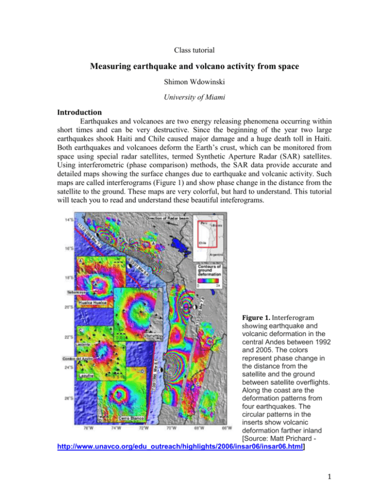
Class tutorial Measuring earthquake and volcano activity from space Shimon Wdowinski University of Miami Introduction Earthquakes and volcanoes are two energy releasing phenomena occurring within short times and can be very destructive. Since the beginning of the year two large earthquakes shook Haiti and Chile caused major damage and a huge death toll in Haiti. Both earthquakes and volcanoes deform the Earth’s crust, which can be monitored from space using special radar satellites, termed Synthetic Aperture Radar (SAR) satellites. Using interferometric (phase comparison) methods, the SAR data provide accurate and detailed maps showing the surface changes due to earthquake and volcanic activity. Such maps are called interferograms (Figure 1) and show phase change in the distance from the satellite to the ground. These maps are very colorful, but hard to understand. This tutorial will teach you to read and understand these beautiful inteferograms. Figure 1. Interferogram showing earthquake and volcanic deformation in the central Andes between 1992 and 2005. The colors represent phase change in the distance from the satellite and the ground between satellite overflights. Along the coast are the deformation patterns from four earthquakes. The circular patterns in the inserts show volcanic deformation farther inland [Source: Matt Prichard http://www.unavco.org/edu_outreach/highlights/2006/insar06/insar06.html] 1 Background The central Andes is a tectonically very active region situated along the Pacific coast of South America. The Andes are the product of rapid convergence between the Nazca and South American plate, which has occurred over the past 130 million years. The same processes that have formed the Andes are active at present, which include periodic energy release by earthquake and volcanoes. Earthquakes release the elastic energy accumulated along the interface between the two tectonic plates, due to the convergence motion between Nazca and South American plates. Volcanoes release energy that accumulates as pressurized magma above the subduction zone. InSAR (Interferomteric Synthetic Aperture Radar) is a very powerful technique that measures phase change along the line of sight (LOS) between the satellite and the ground. The method provides detailed maps of phase change (e.g., Figure 1) that can be converted to surface movements and teach us about crustal deformation processes, including earthquakes and volcanoes. The key steps in using and understanding interferograms are: 1) Mapping phase changes – interferogram generation. This step requires the usage of dedicated software and a lot of number crunching. We will skip the interferogram generation in the tutorial. However, we will use a processed interferogram to understand phase change distribution and characteristics. 2) Phase unwrapping – the mapped phase is wrapped in the range 0-2. In this stage, we unwrap the phase to obtain continuous surface change patterns. 3) Conversion to LOS distance based on the sensor’s data type. 4) Conversion of LOS to surface displacement. 5) Geological interpretation. Objectives This tutorial is based on real InSAR observations acquired over the Andes from 1992 to 2005. It will get you acquainted with InSAR observations and basic concepts of space geodesy. The starting point is processed interferograms, which use a color scheme to display the detected phase change in the range of 0-2 (Figure 1). The tutorial will guide you how to unwrap the phase and convert the measurements to displacements. The calibrated interferograms will allow you to detect earthquake and volcano deformation patterns and learn about tectonic activity in the Andes. 2 Interferograms In this tutorial we use two interferograms (Figure 2) showing different fringe patterns. The interferograms were calculated by Matt Prichard (Cornell University). Figure 2. Two interferograms showing phase change due to deformation in the central Andes. Question 1: What is the difference between the two fringe patterns shown in Figure 3? What do you think can be the causes for the observed differences? Part 1: Plot two profiles across the two interferograms (A-A’ and B-B’), one for each interferogram, showing phase changes as distance from the coastline in A and the center of the circular pattern in B. Each profile has a series of saw tooth shapes. The vertical side is in the yellow-red-purple. Question 2: What do these profiles show? What are the differences between the two profiles? 3 Part 2: Unwrap the phase (extend the phase range beyond the 0-2) to obtain a more physical meaning of these phase observations. Plot the unwrapped phase in the two graphs below. Question 3: What do these unwrapped profiles show? What are the differences between the two profiles? Part 3: Convert the phase observations to displacements using the following relations between line of sight (LOS) length change and phase change (). Calculate the displacement for a single fringe cycle ( = 2) and use this value and its multiples to convert the unwrapped phase to displacement. Add your results to the right hand-side vertical axis. LOS 2 2 (1) is the signal wavelength. It value can be found in the Table 1 (below). Table 1. SAR acquisition parameters used in this study. Parameter Radarsat-1 Wavelength 5.6 cm Incidence angle 23 deg 4 Part 4: Assuming that the phase change reflects only vertical displacement, use the equation below to convert the LOS change observations to surface displacements. h LOS 1 1 cos 2 2 cos (2) where h is the height change, and is the incidence angle. The incidence angle value is provided in Table 1. The (-) sign reflects the inverse relations between LOS changes and surface changes.Assuming that the satellite is in the same position in space, longer LOS corresponds with surface subsides and shorter LOS with surface uplift. Calculate height change for a single fringe cycle ( = 2) and use this value and its multiples to convert the unwrapped phase (and LOS) profiles to displacement. Plot your result in the two profiles below. Question 4: What are the maximum displacements that can be detected in each profile? Question 5: Is the assumption of converting the phase to vertical displacement is good for the A-A’ profile and for the B-B’? Explain. 5 Part 5: Now expand your height-phase knowledge to the entire interferograms using the contour maps below. Each contour is of 0/2 of the wrapped phase. First, select and plot a color scheme in the scale bar that extends the entire range of displacement in the interferogram. Then use this color scheme to color the map below according to the phasedisplacement relations. Figure 3. Base map for plotting the InSAR-based map of water level changes. The maps show the 0/2 contours of the wrapped phase. Tectonic significance 6
